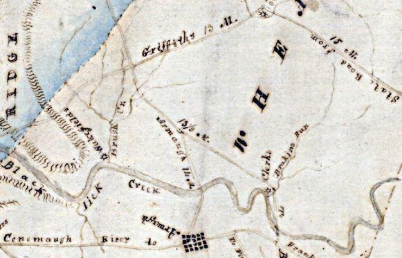
001004-02: Map, 1817
16 April 1817
Detail near Armagh, Indiana, Pennsylvania from the Melish-Whiteside map of 1817. The area was then in Wheatfield Township, Indiana County, Pennsylvania. Indiana County, Pennsylvania formed in 1803. Pine Township incorporated in 1850 and became Buffington Township in 1867.
To the northeast of Armagh, along Blacklick Creek is "Brakins Run" or Bracken's Run. The site of a grist mill is also shown. Although William Bracken apparently built and operated the original mill as early as 1774, it may have been replaced and/or owned by someone named Clarke by 1817, some forty years later.
The original properties of John Stewart [00249] and Charles Stewart [00260] were situated to the west of the head waters of Bracken's Run, which is the area north of Blacklick Creek where Bracken's Run begins. Since it is an old map, it of course is not very accurate.
Source: "Indiana County, Pennsylvania 1817 Whiteside Map," images, Carla A. Currie, Treasures of the Past (http://freepages.genealogy.rootsweb.ancestry.com/~treasures/pa/indiana/maps/: downloaded 27 November 2010), Map of Indiana County, Pennsylvania, 1817; citing Melish-Whiteside maps 1816-1821.
Citation: Mike Voisin, iSeeAncestors (https://iSeeAncestors.com/tree/groups/public/media/si-00048-i249-08.php : revised June 12, 2023), Gallery.
Revised: June 12, 2023
Copyright © 2000-2023 Mike Voisin. All rights reserved.
