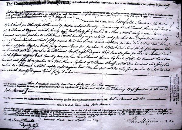
001229: Land Patent
28 March 1799
Land patent (deed) granted to John Stewart [00249] by the Commonwealth of Pennsylvania for a tract of land called "Cornfield" near Black Lick Creek in Wheatfield Township, Westmoreland, Pennsylvania, dated March 28, 1799.
Source: "Commonwealth of Pennsylvania to John Stewart," Land Patent, Pennsylvania Historical and Museum Commission, Record Group 17; Patent Book Volume P-35, Page 245, Pennsylvania State Archives, Harrisburg, Pennsylvania.
Transcription:
The Commonwealth of Pennsylvania, to all to whom these presents shall come Greeting: Know ye, that in consideration of the Monies paid by John Stewart into the Receiver General's Office of this Commonwealth, at the granting of the Warrant hereinafter mentioned and of the sum of one pound nine shillings and six pence lawful Money paid by him into the said office there is granted by said Commonwealth unto the said John Stewart a certain Tract of Land, called "Cornfield" Situate on the Waters of Black [Lick] Creek in Wheatfield Township Westmoreland County. Beginning at a Chesnut [Chestnut]
Thence by land of Nathaniel Bryan. North Seventy deg,s West Sixty four perches to a Post.
North sixty degrees West one hundred and four perches to a Chesnut [Chestnut].
North Twenty degrees West sixty perches to a Dogwood.
Thence by land of James Hunkard South fifty degrees West one hundred and eighteen perches to a White Oak.
Thence by land of John Skyles South forty degrees East ten perches to a Black Oak.
South thirty five degrees West one hundred and ten perches to a Chesnut [Chestnut].
South eight Degrees West Seventy four perches to a Black Oak.
South fifteen degrees East Seventy two perches to a Chesnut [Chestnut].
Thence by land of Charles Stewart East One hundred and fifty three perches to a Post.
Thence by land of William Shaff North One hundred and forty six perches to a Chesnut [Chestnut].
North eighty eight degrees East One hundred and Twenty four perches to a White Oak and
North twenty Degrees East forty Perches
to the beginning, containing Two hundred ninety two Acres forty one perches and allowance of six per cent. for roads &c. [which said tract was surveyed in pursuance of a Warrant dated 13th February 1797 granted to the said John Stewart.]
with appurtenances: TO HAVE AND TO HOLD the said tract or parcel of land, with the appurtenances unto the said John Stewart and his heirs, to the use of him the said John Stewart and his heirs and assigns for ever free and clear of all restrictions and reservations as to Mines, Royalties, Quit-rents, or otherwise, excepting reserving only the fifth part of all gold and silver ore, for the use of the Commonwealth, to be delivered at the pitt's mouth, clear of all charges. IN WITNESS whereof, Thomas Mifflin Governor of the said Commonwealth hath hereunto set his hand, and caused the State Seal to be hereunto affixed the 28th day of March in the year of our Lord, one thousand-seven-hundred and ninety-nine and of the Commonwealth the twenty third.
Inrolled the third day of April 1799
ATTEST James Trimble, Deputy Sec,y
Tho Mifflin (L.S.)
Citation: Mike Voisin, iSeeAncestors (https://iSeeAncestors.com/tree/groups/public/media/si-00048-i249-13.php : revised June 12, 2023), Gallery.
Revised: June 12, 2023
Copyright © 2000-2023 Mike Voisin. All rights reserved.
